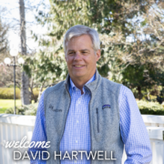
Join us in welcoming David Hartwell to our Board of Directors!
March 20, 2026-
Residing in Minnesota, David is semi-retired after a long stint in various manufacturing businesses, the longest being 27 years in the composites industry, where he built a company with manufacturing capacity of 50M square feet annually. He currently serves on numerous company boards and as an advisor to various businesses.
He also has extensive experience on non-profit, foundation, and governmental boards. He was the founding president of the Minnesota Land Trust and served on the Land Trust Alliance board in numerous capacities for 23 years. In 2000, he launched and then led an effort which resulted 8 years later in a constitutional amendment raising the sales tax in Minnesota that is now providing $450M annually for habitat, clean water, parks and cultural habitat. David graduated from the school of hard knocks, is married to Amy Hartwell, whom he travels extensively with, is an avid birdwatcher and gardener and has a blended family of 7 children, 8 grandchildren and one great granddaughter.
The Trust’s volunteer Board of Directors has 17 members, spread across the country. Their extensive and invaluable expertise help to steer the Trust’s work as our governing body. We look forward to all that David will bring to our Board!
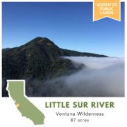
Trail access, redwoods, and steelhead spawning grounds protected in California’s Central Coast
March 6, 2026-
Along California’s Central Coast, the Pacific Ocean meets mountains in one of the nation’s most significant biodiversity hotspots. Here, over 35 endangered species make their homes in the narrow canyons, chaparral, and old-growth forests. The Ventana Wilderness protects over 240,000 acres of this critical habitat. In 2020, a family wishing to see this landscape they love protected for future generations generously donated their 87-acre property to The Wilderness Land Trust. The Trust recently transferred the property, known as Little Sur River, to public ownership to be added to Los Padres National Forest.
The Little Sur River property sits between the Ventana Wilderness to the south and another section of Los Padres National Forest, which was previously landlocked by private property, to the north. Its transfer to public ownership has not only connected those two sections of public lands, it has also ensured public access on two trails running through the property
“Our gratitude goes out to the Wilderness Land Trust for leading the effort to add the Little Sur River parcel to our treasured public lands,” says Ventana Wilderness Alliance Executive Director, Carol Olson. “This transfer of private lands to public ownership advances our shared goal to protect wilderness values in the Big Sur backcountry.”
This transfer has also protected a tributary to the South Fork of the Little Sur River, the Central Coast’s most important and pristine spawning grounds for the threatened South-Central Coast steelhead trout. Today, only an estimated 100 fish return to the Little Sur River each year to spawn, making every foot protected of its sheltered cold water tributaries critical for their survival. The property is also home to an old-growth stand of coastal redwoods, which can grow to over 350 feet in height and live for 2,000 years.
This is the 7th property protected by the Trust in and around the Ventana Wilderness, totaling over 830 acres.
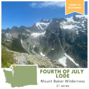
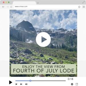
Washington’s Mt. Baker Wilderness grows with transfer of inholding property
February 20, 2026-
The Wilderness Land Trust recently completed the transfer of 21 acres within Washington’s Mount Baker Wilderness to public ownership, adding it to the designated wilderness area.
Within the Fourth of July Lode property, high in the alpine, sits one of the remaining 13 glaciers in the Mount Baker Wilderness. Glaciers across the North Cascades have been steadily losing volume over the last several decades. As glaciers shrink due to a changing climate, the ecosystems that depend on them become increasingly vulnerable. A study found the Mt. Baker-Snoqualmie National Forest provides $30 billion worth of ecosystem services that we depend on, like the clean air and clean water which sustain life, and every dollar invested in the Forest returns over $3,000 in ecosystem services.
Removing this threat of development from the Fourth of July Lode property will not only yield returns for future generations through these ecosystem services, but also help bolster the resilience of the surrounding wilderness ecosystems by improving their connectivity.
 The Trust first purchased the property from a private owner whose family it had been in since the early 1900s gold rush. Now that it has been transferred to public ownership it is protected as designated wilderness, which enjoys the highest level of protection available to public lands that can only be altered by an act of Congress, not executive orders or other administration directives.
The Fourth of July Lode property is the 16th property the Trust has transferred to public ownership in Washington within the last year as part of our North Cascades campaign.
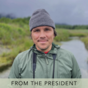
A message from our President
February 6, 2026-
Dear Friends,
I’m writing to introduce myself and say how excited I am to be joining this community as President of The Wilderness Land Trust.
For much of my career, I’ve worked at the intersection of wilderness conservation and storytelling, helping locals seek more durable protection for their big backyards- the places they grew up hunting, fishing, hiking, or paddling.
And if there’s one thing I’ve learned from almost two decades of engagement on preserving the shared heritage of our public lands, it’s that there are no quick wins. Instead, building reliable partnerships through patience and persistence is what carries the day. That kind of work requires discipline, trust, and a long view… qualities that I’d say feel especially important right now, as pressures on wild lands continue to grow and the pace of decision-making accelerates around them.
Patience. Persistence. Discipline. Trust. The Wilderness Land Trust has long embodied those values. Quietly, thoughtfully, and often without fanfare, the Trust has stepped in where others couldn’t, ensuring that extraordinary landscapes are made complete. I’m honored to help carry that work forward.
In fact, one of the things that drew me most strongly to the Trust is its unique role on the conservation spectrum. There are plenty of groups doing good work to expand the National Wilderness Preservation System, and plenty of groups doing good work to steward the lands in that System, but in the middle one finds The Wilderness Land Trust, doing very good work to make that system whole and healthy.
I feel lucky to be supported in our work by a world-class staff and a stellar Board of Directors. Together, we intend to continue to strive to preserve a rich legacy of protected wilderness through persistent, professional, and fair acquisitions of private land in and around wilderness areas, to help complete the promise of wilderness. Our work as a reliable partner to agencies and local communities will endure. And we’ll continue to steward our resources responsibly, knowing that every acre protected represents a promise kept.
We do all this because we know how meaningful wilderness is to you and your family, generating stories of adventure, discovery, and inspiration. These are special places that you and I both cherish, and that we both hope will remain wild and free. As an organization, we are motivated by the same values as you: a reverence for the land and the complex communities of life it supports.
Thank you for being part of this community and for supporting The Wilderness Land Trust. I’m excited for the work ahead, and I look forward to learning from you as we continue it together.
With gratitude,
Anders Reynolds
President, The Wilderness Land Trust
anders@wildernesslandtrust.org
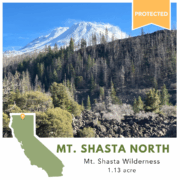
Mt. Shasta inholding protected
January 23, 2026-
The Wilderness Land Trust recently acquired a 1 acre inholding within the Mount Shasta Wilderness of northern California. You may be wondering why bother protecting one acre within the almost 37,000 acre wilderness area? But every inholding, no matter their size, is a tear in the fabric of wilderness protection.
The Mt. Shasta North property is home to an ancient lava flow from the still active volcano, and has sweeping views of the summit to the southeast and broad valleys to the west. Located only 1/4 mile off a trail, it had been purchased by the previous landowner with the intention of building on it. Now that the property has been protected, there are only three inholdings left within the Mt. Shasta Wilderness, making this acquisition a meaningful step toward completing the wilderness area.
Once the property is transferred to public ownership and added to the designated wilderness, we’ll have mended the tear, removing the gap in habitat connectivity and making the fabric of wilderness as whole stronger than before.
Saying farewell to Brad Borst
January 23, 2026-
Next week we’ll be saying farewell to Brad Borst after 9 years serving as the Trust’s president. If you’ve had the good fortune to interact directly with Brad during his tenure, you’ll know how dedicated, thoughtful, humble, and kind he is, and it will likely come as no surprise that he’d rather focus on the exciting next chapter for the Trust under Anders Reynolds’ leadership than have a fuss over him. But we’d be remiss to let him go without celebrating him and acknowledging all he’s given to the Trust.
“Brad’s steady leadership and unwavering dedication to the Trust have left a lasting imprint on both our organization and our mission. Under his guidance, the organization has matured into a resilient, sustainable institution, one that is equipped to remain relevant in the face of rapid ecological, climatic, and political change. Thank you, Brad, for keeping the promise of wilderness in your heart and in your hands. Happy trails,” says Trust board chair Sarah Chase Shaw.
Brad has helped to grow the Trust, adding new staff capacity, expanding our work east of the Rockies, and building new funding relationships to make our work possible. He has steadily guided the organization through the uncertainties of the pandemic and shifting administration priorities. Brad has created and nurtured a culture at the Trust that is truly a joy to be a part of, where staff are supported and cared for— he is the rare kind of leader who is wholeheartedly dedicated to serving those around him.
We are so grateful for Brad’s dedication and the opportunity to work alongside him. Join us in wishing Brad the best in wherever the trail takes him next!
Introducing the Trust’s new President: Anders Reynolds
January 9, 2026-
As many of you know, Brad Borst is stepping down after nine years at the helm of The Wilderness Land Trust. Over the past several months, our board of directors has undertaken a national search for our next leader to carry forward the Trust’s mission.
We are thrilled to announce that Anders Reynolds will be joining the Trust as President on January 15th! Originally from Wynne, Arkansas, Anders attended Rhodes College and Johns Hopkins University. For the majority of his career, he’s engaged federal lawmakers on public land policy, most recently with the Southern Environmental Law Center and Pew Charitable Trusts. In those roles, he’s proud to have played a part in achieving durable wilderness protection for landscapes in Tennessee, Arkansas, Colorado, Nevada, and Southern Utah. His work has included building resilient coalitions of diverse stakeholders, offering policy expertise to federal decision-makers, and amplifying the passion of local advocates who love their big backyards just the way they are. He has extensive federal and state campaign experience and previously worked on Capitol Hill. He has also served as Board Chair of both the Southern Appalachian Wilderness Stewards and the Virginia Wilderness Committee. In his free time, Anders is an avid runner, a crossword completist, a pizza enthusiast, and the proud companion of two dumpster dogs, Crash and Cora.
As the Trust continues to navigate uncertainty in the national wilderness conservation landscape, Anders’ expertise in engaging local communities and federal decision-makers alike will be invaluable. “We are thrilled to welcome Anders as our next President. His passion for wilderness is palpable, and his leadership will propel The Wilderness Land Trust’s mission forward at a pivotal moment. A natural problem solver, Anders understands the power of partnerships in addressing complex challenges, and his vision will help advance a seamless wilderness system that honors the spirit and intent of the original Wilderness Act” says Sarah Chase Shaw, board chair.
Vice President and Senior Land Specialist Aimee Rutledge adds, “The staff are all very excited about Anders joining the Trust. He brings deep experience with wilderness, intelligence, and team-building skills to navigate challenges, develop opportunities, and deepen the Trust’s impact.”
Brad will stay on through the end of January to work with Anders and the staff to ensure a successful transition. “The Wilderness Land Trust’s reputation precedes it, and I couldn’t be more thrilled to be joining this hard-working staff and board in their efforts to protect wild places before they’re lost,” says Anders. “From ensuring recreation access to protecting watersheds, wilderness is the gold standard protection for the public lands that we all share. Making whole those shared landscapes only happens when an organization is willing to plan smartly, step in early, and work tenaciously. That’s the model The Wilderness Land Trust has refined over decades, and it’s the work I’m excited to lead. I look forward to connecting with you, our partners and supporters, in the coming weeks and months.” You can reach Anders at Anders@wildernesslandtrust.org
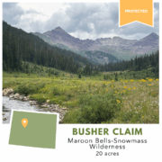
Private inholding in Maroon Bells-Snowmass Wilderness Protected
December 12, 2025-
The Wilderness Land Trust has protected a 20-acre inholding property within the Maroon Bells-Snowmass Wilderness. The property, known as the Busher Claim, was privately owned with mining claims dating back to 1884. The Trust purchased the property with the goal of transferring it to public ownership to be added to the wilderness area.
The Busher Claim property sits on the slopes above the popular hiking destination of Cumberland Basin, below Pearl Mountain and Castle Peak. Its fragile high-alpine ecosystem provides important wildlife habitat as well as pristine viewsheds for recreationists. Because it is located near the Pearl Pass Road, an OHV route from Aspen to Crested Butte, the property was at higher risk of development.
The property has now been protected from development thanks to the generous support of Trust donor Kim Kanas of Longmont, Colorado through the Wilderness Opportunity Fund. Once transferred to public ownership, it will enjoy the highest level of protection available to public lands as designated wilderness, which can only be altered by an act of Congress, not through executive order or administration directive.
To date, The Wilderness Land Trust has protected 35 properties in the Maroon Bells-Snowmass Wilderness, including recently partnering with Pitkin County on the landmark conservation deal to protect the 650-acre Snowmass Falls Ranch outside Snowmass Village.
Private inholdings protected in Maroon Bells-Snowmass and Weminuche Wilderness Areas, a win for recreationists
December 3, 2025-
The Wilderness Land Trust has recently protected three private properties within Colorado wilderness: the 20-acre Busher Claim in the Maroon Bells-Snowmass Wilderness, the 30-acre Needle Creek property, and the 31-acre Great Western Lode in the Weminuche Wilderness
The properties were previously privately owned, and at risk of development. Nationwide there are over 275,000 acres of private property, known as inholdings, within designated wilderness areas. Unlike the surrounding wilderness, they are not protected and can be developed with homes, resorts, timber, and mining operations. The Wilderness Land Trust works with willing sellers to purchase these properties and protect them to benefit public access, wildlife habitat, and healthy watersheds.
 The Busher Claim, which the Trust recently purchased, sits on the slopes above the popular hiking destination of Cumberland Basin, below Pearl Mountain and Castle Peak. Its fragile high alpine ecosystem provides important wildlife habitat as well as pristine viewsheds for recreationists. Because it is located near the Pearl Pass Road, an OHV route from Aspen to Crested Butte, the property was at a higher risk of development. It has now been protected from development thanks to the generous support of Kim Kanas of Longmont, Colorado. With the acquisition complete, the Trust will now work to transfer the property to public ownership.
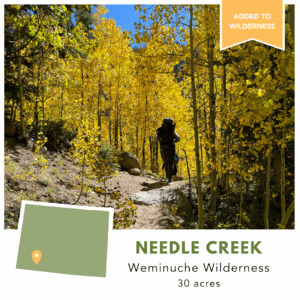 The Needle Creek property was acquired by the Trust earlier in 2025, and has now been transferred to public ownership and added to the Weminuche Wilderness. Running through the property are both Needle Creek and the Needle Creek Trail, which is used by hikers and climbers to access the very popular Chicago Basin and its surrounding 14,000+ peaks. With flat, buildable stream-side sites, the property was previously at risk of development. Now protected, public access on the trail to Chicago Basin has been ensured for future generations to enjoy. Needle Creek is an important tributary to the Animas River. This water source, along with vibrant aspen groves that stretch from the creek up the slopes of the Needle Mountains, create habitat for a wide range of wildlife. The Needle Creek property scores high for climate change resilience, biodiversity, and landscape connectivity, all important conservation values that will be protected as wilderness.
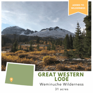 The Great Western Lode, which the Trust acquired in 2022, was also recently transferred to public ownership. Located about five miles north of the Needle Creek project in the Weminuche Wilderness, the property protects fragile alpine tundra habitat. Like the Needle Creek project, the addition of Great Western Lode to the wilderness area secures public access on a popular trail. The Whitehead Trail runs through the property and connects the Continental Divide Trail, a National Scenic Trail from Mexico to Canada, to the Highland Mary Trail and Deer Park Trails, which are easily accessible from the town of Silverton, Colorado, a year-round recreation destination. All but 6 acres of Great Western Lode have been added to wilderness area, with the remaining 6 acres, which extends outside of the established wilderness boundary, added to San Juan National Forest to be managed as wilderness.
These properties will be protected as designated wilderness, which enjoys the highest level of protection available to public lands that can only be altered by an act of Congress, not executive orders or other administration directives.
To date, The Wilderness Land Trust has protected 198 properties in Colorado, totaling over 7,300 acres. The Trust’s work to protect Colorado’s most wild landscapes can be supported during Colorado Gives Day on December 9th at https://www.coloradogives.org/organization/Wildernesslandtrust, or anytime at www.wildernesslandtrust.org/get-involved/donate-now/
In the organization’s 33-year history, The Wilderness Land Trust has worked to keep the promise of wilderness by acquiring private land in and around wilderness from willing landowners and transferring them to public ownership. In this time, the Trust has purchased and transferred 616 properties totaling over 59,000 acres from Arizona to Alaska, completing 18 wilderness areas by removing their last remaining private inholdings. With each transfer, we come one step closer to completing the vision of the Wilderness Act.