April 18, 2025-
Unless you’re a wilderness practitioner or researcher, you probably haven’t been keeping up with the debate playing out in the pages of the International Journal of Wilderness about the intersection of virtual reality and wilderness.
Through a series of articles, Keely Fisher, a researcher at Ohio State University, and writer Paul Keeling explore how the advent of virtual reality (VR) is impacting our connection to and conceptualizations of wilderness. Through these VR experiences, users can traverse a trail or take in the views from a mountain peak through a “computer-simulated environment using graphics and specialty hardware that allows for a person to control their point of view and creates a completely immersive and realistic experience”.
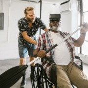
Fisher points out that people have always related to wilderness through documentation of it, whether in paintings, photos, or video. Experiencing these representations of wilderness can often evoke the same emotions as in-person wilderness experiences, like awe, wonder, and inspiration. Fisher’s research shows that these emotions can also be triggered by VR experiences of wilderness, as can many of the (physical and mental) health benefits of time spent in nature, especially for those not physically able to visit wilderness due to age or disability. In short, Fisher concludes that while VR and real-world wilderness experiences are not the same, VR can evoke some of the same benefits, including fostering a connection between people and wild places which can be important in their protection.
Keeling, on the other hand, views VR representations of wilderness as antithetical to the idea of wilderness itself: “What is admirable and valuable in wilderness are (among other things) the other-than-human forces that have contributed to its making independently of human purposes. A wilderness experience machine, on the other hand, is wholly the product of human purpose, intention, and design, which explain its very existence.” For Keeling, while experiencing the documentation of wilderness through a VR experience may give the viewer some of the same psychological and health benefits as an in-person experience of the same place, the fabrication of the experience is not equal to the experience itself, and while “such virtual wilderness experience might point to real wilderness as something worth connecting to but would not itself be a connection with wilderness at all.”
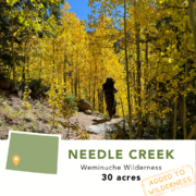
As is the case for many academic debates, their back and forth becomes semantic at points. But it reminded me of the diversity of perspectives and experiences of wilderness that we often see reflected when talking to our community of Trust supporters and partners. While designated wilderness is defined in the 1964 Wilderness Act, what the concept of wilderness means, and how we experience it, is different for each of us. For some, their connection to wilderness comes from experiences in the wildest landscapes they can find, far from crowded trailheads or cell service. For some, car camping in a state park or a hike on a close-to-home trail evoke the same feelings of appreciation for the natural world that drive their support of wilderness conservation. And for others, it is that wilderness exists absent of people and their experience of it that makes it so valuable. Our own personal relationships to wilderness are also likely to shift over our lifetimes, as our physical abilities may change, as we bring along small children, or as where we live and what is accessible to us change.
One of the most inspiring parts of our work at the Trust are these conversations we have when we sit down with a donor, landowner, agency or community partner and see where our own unique sets of values and experiences overlap with the Trust’s mission. No one perspective is more valuable than another. What is considered wilderness and how we should relate to it isn’t dictated in the pages of an academic journal, it is a reflection of our ever evolving personal and collective understanding of it. So whether the idea of putting on a set of VR goggles to revisit a favorite trail appeals to you personally, it doesn’t mean it can’t be a meaningful experience for someone else. Wilderness itself brings together people with diverse backgrounds and points of view, and we should ensure that we create space in our community of wilderness lovers and advocates where all are welcome.