Tag Archive for: conservation

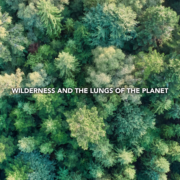
Wilderness and the lungs of the planet

July 26, 2024-

Increasingly, summer in the West has become synonymous with wildfire season. As of this week, 89 large wildfires are active in the US and have burned 1,611,409 acres. But the impacts of those fires reach far beyond the communities directly affected by them, as smoke blankets much of the country, reaching through the Midwest and New England and well into the Atlantic Ocean. With it comes impacts ranging from reduced visibility to unhealthy air quality.

Map showing the extent of current wildfire smoke from fire.airnow.gov

It’s hard to say whether to call it irony or a perfect example of the balance and interconnectedness of the natural world that the same forests that cyclically burn also help to purify the air of smoke caused by those fires. Forests are often called the lungs of the world for how they help to remove pollutants from the air, ranging beyond smoke to carbon dioxide, sulfur dioxide, and particulate matter. Our nation’s forests offset around 13% of our greenhouse gas emissions every year. Of course, these benefits are provided beyond the boundaries of wilderness areas: roughly 30% of the US is forested, but only 4.5% is wilderness. Urban trees and forests can be particularly impactful as well, as a single tree can absorb 10 pounds of pollutants and 48 pounds of carbon dioxide each year. Interestingly, some trees are more efficient at removing pollutants from the air: the needles of coniferous trees can continually absorb pollutants for several years, while the broader leaves of deciduous trees have more surface area for particulate matter to attach to. “The various species differed more than we expected. Larch, which is a conifer that sheds its needles each autumn, was best in test. Larch trees absorbed the most particle-bound pollutants, but were also good at capturing gaseous PAHs,” found one study.

Clean air is one of the many benefits that wilderness provides, but it is also one of the requirements of protection of wilderness. While the Wilderness Act does not call out clean air as one of the characteristics of wilderness to be preserved in its natural state, the Clean Air Act does categorize wilderness areas larger than 5,000 acres that were established prior to 1977 (totaling 139 of 806 designated wilderness areas) as the highest level of mandated protection against air pollution (with all other wilderness areas are categorized as the second highest level of protection). Development of private lands in and around wilderness areas can be a major source of local air pollution emissions. By limiting this development we are not only aiding in the protection of wilderness character, we are protecting the forest ecosystems which remove pollution from the air.

More broadly, protecting large connected ecosystems in their natural state allows these natural processes and cycles, which are nothing short of miraculous in their efficiency and ingenuity, to go on unimpeded. While technology can offer additional options for removing pollutants from the air, which will likely be increasingly needed to mitigate the climate crisis, you don’t have to look farther than out your window, at the nearest tree, for the original technology of the lungs of the planet.


Get more wilderness news delivered to your inbox!


By submitting this form, you are consenting to receive marketing emails from: Wilderness Land Trust. You can revoke your consent to receive emails at any time by using the SafeUnsubscribe® link, found at the bottom of every email. Emails are serviced by Constant Contact

Mapping threats to the wilderness you love

July 12, 2024-

When we set out last year to begin creating a first of its kind GIS-based national inventory of private properties in and around wilderness, we knew we’d need help. We knew what the challenges of our current, largely analog system of inventorying wilderness inholdings are, we knew what we were hoping to accomplish with the help of this new GIS tool, but we only had a passing knowledge of the GIS technology itself. So, we began engaging with experts in the field to understand what resources were already out there and how we might go about carrying out this ambitious project. As is often the case when you have limited knowledge and are talking to someone with vast knowledge, it can be hard to know what you don’t know, and even to know what the right questions to ask are, let alone the right terms to use in asking.

In discussing where to begin, Brad, our President, mentioned “You know, I’ve met one of our supporters in Washington named Stu Smith who is a retired GIS professional. He might be willing to talk with us to answer some questions”. Little did we know that not only would Stu graciously be willing to answer some questions, he’d become an integral part of the project.

Stu Smith enjoying a recent trip outside the Tracy Arm-Fords Terror Wilderness in SE Alaska

Growing up in rural Oregon as the son of a forester, Stu knew he was destined for a career involving the outdoors and natural resources. From an early age he studied the maps and aerial photographs his dad would bring home. After working as a wildland firefighter through college, he earned a PhD in plant ecology. At the time GIS, short for Geographic Information System, was in its infancy, but Stu became fascinated with how it could connect his work in ecology collecting field data and analyzing it with statistics with his love for maps. Soon after Stu decided to pursue a career in GIS.

Stu describes GIS as a big map overlaid with transparent sheets showing things like land ownership, soil types, watersheds, and wildlife migration corridors, all georeferenced, or lined up with the map and each other. These sheets can be viewed in any combination to see how they intersect, and even how they change over time.

For our inventory purposes, we needed to collect and organize the electronic data layers of designated wilderness areas, proposed wilderness areas and other relevant conservation designations, as well as private properties in and around them. It sounds simple enough, but with 180,000,000 land ownership parcels recorded by 3,200 counties across the US (each with its own slightly different method of keeping and naming records), it is no easy task. When you think about all the different combinations and permutations of how these parcel layers can intersect, the possibilities quickly multiply. That is where Stu stepped in. Volunteering his time, he expertly crafted the algorithms to have the GIS software identify private inholdings within wilderness, edgeholdings that adjoin wilderness, and outholdings that may be important for protecting wilderness values. Essentially this created the first-ever complete national inventory.

Now we are hard at work ground-truthing it to refine those algorithms. Where are the boundaries shown by different data sources in conflict? Of the inholdings identified, which are privately owned vs. state or tribally owned? Which are owned by other land trusts or conservation groups? Which counties are recording things like grazing leases on public lands in the same way as private ownership? Our partners around the country are applying their local knowledge to help us with this work, as well as to provide GIS layers for proposed wilderness or other conservation priorities. With each step of this process, our inventory becomes more refined, and the full picture of the need and opportunity for protecting private lands in and around wilderness comes into sharper focus.

This screenshot taken from our GIS mapping tool shows how we can easily identify wilderness inholdings that are entirely within the wilderness (red), as well as edgeholdings that are partially within or adjoining the wilderness (purple). It also identifies properties not within or adjoining the wilderness (yellow) for which protection might benefit wilderness values. The tool also allows us to easily identify ownership– in this case these properties are owned by the Trust, and are part of our 183-acre Cross Mountain project in Colorado which will soon be transferred to public ownership.

Already this tool is providing huge benefits to our work. In the coming months, we’ll continue to refine it and build the additional capacity in it to analyze parcels for various development threats and conservation values using local, regional, and national data layers. Soon we look forward to making it available to share with land management agencies and other conservation organizations to aid in their work as well.

Beyond the many many hours of his time he has donated, Stu’s vision and discerning eye have brought immense value to the project, and we are beyond grateful. For his part, Stu says “I’m just happy to be the right person at the right time to be able to help the Trust”.

The initial investment to build our GIS program over the next three years will require $200,000 in capital, with an ongoing annual cost of $52,000. Donate today to support this work.


Get more wilderness news delivered to your inbox!


By submitting this form, you are consenting to receive marketing emails from: Wilderness Land Trust. You can revoke your consent to receive emails at any time by using the SafeUnsubscribe® link, found at the bottom of every email. Emails are serviced by Constant Contact

The Best of Field Season

June 28, 2024-

With snow melting out of the high country and summer officially upon us, field season is beginning for our lands staff. Over the next few months our team will be visiting project sites in wilderness areas across the country. Site visits are an integral part of our work: they allow us to do important due diligence on prospective properties, to plan and complete restoration work to return properties to their wilderness character before transfer to public ownership, and to meet with the private landowners and partner organizations and agencies that make our work possible. Having boots on the ground not only allows us to access the specific conservation values of each property in order to maximize our impact, the stunning vistas, wildlife sightings, and moments of solitude remind us why we do what we do.

Due to the remote nature of our project sites, each visit comes with its own set of challenges and rewards. Your support makes these visits, and in turn our work, possible.

Most Rugged 
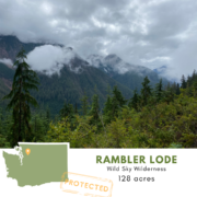
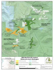
Access: Wild Sky Wilderness, Washington

The Trust has protected 28 properties in the Wild Sky Wilderness, and its steep terrain coupled with the thick undergrowth of its temperate rainforest have earned them a reputation for some of the most difficult to access. The many hours of off-trail bushwhacking aren’t without payoff though, as breaks in the vegetation provide incredible views of pristine alpine lakes and craggy high-peaks. Despite the challenging access, with 15 active projects in this one wilderness area, our staff is able to visit them all relatively efficiently, and is working to transfer the majority to public ownership in one package.


Best Company: Spring Canyon- Gila Wilderness, New Mexico

This week our staff visited the 40-acre Spring Canyon property we are working to acquire to assess its condition and characteristics. While our site visits often include partners such as agencies, local nonprofit, tribes, and technical services like appraisers and surveyors, the company on our Spring Canyon visit was notable. We visited the property with the US Forest Service on horseback, and our trusty mounts Pablo and Sino not only safely carried us across high mesas and down steep canyon walls, they brought smiles to our faces all day. Sino was recently featured in a NY Times article celebrating the centennial of the Gila Wilderness, so we were all very humbled to be in the presence of such a celebrity.


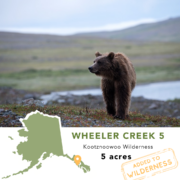
Most Surprising Find: Wheeler Creek- Kootznoowoo Wilderness, Alaska

Every property we work to protect has its own unique history, and oftentimes traces of that history are left behind. Our staff has found no shortage of surprising and sometimes baffling remnants deep in the wilderness, from school busses to mining equipment to metal drums full of mystery chemicals. Visiting projects to assess what restoration work will be necessary to return it to its wilderness character is an important step in our work. But the most surprising site visit find in recent memory wasn’t what we found on the property, it was finding that the property itself had grown. Throughout Southeast Alaska, as glaciers shrink the land is rising in response to the reduced weight of the glaciers in a process known as isostatic rebound. As it rises, more land is exposed above the high-water line. In completing a survey as part of our due diligence we found that the Wheeler Creek property had actually grown by less than an acre since its last survey.

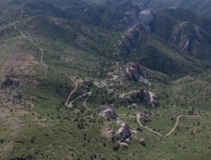
Most Likely to Need Rental Car Insurance: Cougar Canyon Wilderness, Utah

Most trips into the wilderness start with a long drive on rough roads, but some really take the cake. Having largely washed out from spring runoff, the road in to our Cougar Canyon property in SW Utah made for a particularly adventurous trip in for us and our poor rental truck on our last visit. The road forms the boundary of the wilderness area and provides access to the 700-acre property. Despite the current state of the road, in the Washington County real estate market which includes both St. George and the property (and is the fastest-growing metro area in the US) the property is highly vulnerable to development. So, to the folks at Enterprise and Hertz, you have our apologies and thanks for helping us protect this special place!

This week marks the end of our fiscal year. If you haven’t already, please consider making a donation to help fund not only our summer field season, but our work all year round.


Get more wilderness news delivered to your inbox!


By submitting this form, you are consenting to receive marketing emails from: Wilderness Land Trust. You can revoke your consent to receive emails at any time by using the SafeUnsubscribe® link, found at the bottom of every email. Emails are serviced by Constant Contact

Holy Cross wilderness expands with new transfer in Colorado

June 14, 2024-

The Wilderness Land Trust recently transferred our 22nd property in Colorado’s Holy Cross Wilderness to public ownership.

Just down the ridgeline from Homestake Peak, the 10-acre Northern Lode property straddles the Continental Divide in an area once active with mines. It sits just above the the West Tennessee Lakes basin and is a short scramble from the popular trail accessing the lakes.

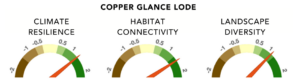
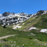
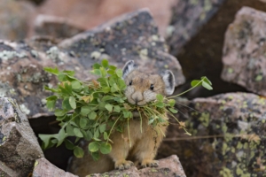
Throughout the property a series of scree slopes and grassy alpine meadows are home to high alpine inhabitants like the American pika. The potato-sized pika is found in the high country throughout the rockies, typically above 8,000 ft. You may have heard their loud squeaking “EEEP” calls or seen them dashing through the talus with mouth full of grasses. In order to make it through the harsh alpine winter without hibernating, the pika will spend all summer stockpiling grass under rocks to dry, creating ‘haypiles’. It’s not uncommon for a single pika to make 25 foraging trips an hour between the talus and meadows through the summer!

The same adaptations that make pika well suited for life in high alpine also make them vulnerable to the climate change. Scientists (including many citizen science programs like the the Colorado Pika Project who rely on volunteers to collect data) are studying how the range of pika habitat is changing, in order to better understand the impacts of climate change. Protecting available habitat, like the Northern Lode property, is important to ensuring these resilient, and adorable, critters continue to thrive.

With five more properties currently held by the Trust awaiting transfer in the Holy Cross Wilderness, our impact there will only continue to grow.


Get more wilderness news delivered to your inbox!


By submitting this form, you are consenting to receive marketing emails from: Wilderness Land Trust. You can revoke your consent to receive emails at any time by using the SafeUnsubscribe® link, found at the bottom of every email. Emails are serviced by Constant Contact

Saying thank you & farewell to wilderness legend Doug Scott

May 17, 2024-

Doug began his work in wilderness conservation just 4 years after passage of the 1964 Wilderness Act, and in the years since has helped establish and expand America’s wilderness areas and grow the wilderness community.

Doug’s fellow board members and staff shared just a few of the many ways Doug’s leadership and expert knowledge has helped The Trust over the years in this short video.

Doug holds a forestry degree from the University of Michigan, where he did his graduate research on the history and drafting of what became the Wilderness Act of 1964. Doug began his own work for wilderness preservation soon after the Wilderness Act became law. As a volunteer activist while in graduate school, a Washington lobbyist for The Wilderness Society, and northwest representative for the Sierra Club, he was in the forefront of many of the important wilderness preservation campaigns as a strategist and lobbyist, including: The Eastern Wilderness Areas Act (1975), the Endangered American Wilderness Act (1978), the Frank Church-River of No Return Wilderness (1980), the Alaska National Interest Lands Conservation Act (1980) and the California Desert Protection Act (1994) among many other wilderness designation statutes.  In the 1980s, Doug was conservation director and, later, associate executive director of the Sierra Club, and in 1996 he received the club’s highest honor, the John Muir Award.

In addition to the many direct contributions Doug has had growing our national wilderness, he is also one of the leading wilderness historians. He is the author of The Enduring Wilderness: Protecting our Natural Heritage through the Wilderness Act and Our Wilderness: America’s Common Ground.

As much as we hate to lose Doug from our board of directors, we look forward to many more years of friendship with Doug! So it’s not ‘goodbye’ it’s ‘see you soon’.


Get more wilderness news delivered to your inbox!


By submitting this form, you are consenting to receive marketing emails from: Wilderness Land Trust. You can revoke your consent to receive emails at any time by using the SafeUnsubscribe® link, found at the bottom of every email. Emails are serviced by Constant Contact

Another gap in protection filled in the Wild Sky Wilderness

May 4, 2024-

The Wilderness Land Trust recently acquired 128 acres within Washington’s Wild Sky Wilderness, building on a years-long effort to unify protection across the landscape.

Looking at a map of the Silver Creek drainage in Washington’s Wild Sky and Henry M. Jackson Wilderness Areas tells a remarkable story of the cumulative impact we are making together in the wild places we love. It tells the story of a spectacular landscape, lush with old-growth forest, home to threatened steelhead trout spawning grounds, with a rich history of mining boom and bust that has left a patchwork of land ownership and protection across the wilderness areas.

As we revise this map we color new parcels in yellow as relationships with landowners deepen and deals to purchase their properties progress, in orange as the Trust acquires properties, and ultimately in green as they are transferred to public ownership and added to the wilderness area. It’s a wonderful sense of accomplishment as one by one we see the blank properties on the map filled in as the threat of their development is removed.

Recently we completed the purchase of the 128-acre Ramble Lode property. It was the Trust’s ninth acquisition within the drainage, and adjoins several already protected properties. With it we have filled another gap in protection in the Wild Sky Wilderness.


Get more wilderness news delivered to your inbox!


By submitting this form, you are consenting to receive marketing emails from: Wilderness Land Trust. You can revoke your consent to receive emails at any time by using the SafeUnsubscribe® link, found at the bottom of every email. Emails are serviced by Constant Contact

More wilderness added to Alaska’s Tongass National Forest

April 5, 2024-

The Wilderness Land Trust recently transferred 5 acres on Wheeler Creek to public ownership in Tongass National Forest, adding it to the Kootznoowoo Wilderness. At over 17 million acres, Tongass National Forest is the nation’s largest national forest, with 35% of it designated as wilderness across 19 wilderness areas.

The Tongass is often called “America’s climate forest” for the carbon it traps and stores. It role in mitigating climate change impacts is unparalleled. The Tongass is also sometimes called “America’s salmon forest’ as its waterways produce a quarter of the West Coast salmon catch, supporting both commercial fishing communities and native subsistence fishing. The Wheeler Creek property has abundant pink salmon and is also important king salmon spawning ground. Kootznoowoo, which means ‘fortress of the bears” in the native Lingít, is on Admiralty Island southwest of Juneau. Aptly named, it has the world’s highest concentration of brown bears in the world – an estimated 1,600 bears, with more than 1 bear per square mile on the island.

At only 5 acres, the Wheeler Creek property is only a drop in the vast landscape of the Tongass National Forest. But with direct boat access to the property, the wilderness inholding was likely to be developed with cabins or even a commercial lodge if not protected. Thanks to our partnership with Southeast Alaska Land Trust, there is one fewer such threat in the heart of this critical habitat.

Interestingly, land on and around the Wheeler Creek property is accreting, or accumulating. As glaciers continue to shrink, the land is rising in response to the reduced weight of the glaciers in a process known as isostatic rebound. As it rises, more land is exposed above the high-water line. When our Wheeler Creek property was recently surveyed it had actually grown (by less than an acre) since its last survey. Across the region this is creating new habitat and exciting conservation opportunities.

The Wilderness Land Trust recently transferred 5 acres on Wheeler Creek to public ownership in Tongass National Forest, adding it to the Kootznoowoo Wilderness. At over 17 million acres, Tongass National Forest is the nation’s largest national forest, with 35% of it designated as wilderness across 19 wilderness areas. 

Get more wilderness news delivered to your inbox!


By submitting this form, you are consenting to receive marketing emails from: Wilderness Land Trust. You can revoke your consent to receive emails at any time by using the SafeUnsubscribe® link, found at the bottom of every email. Emails are serviced by Constant Contact

Maroon Bells-Snowmass Wilderness grows near Crested Butte!

March 22, 2024-

Just 8 miles northeast of the town of Crested Butte, the Queen Basin rises to meet the ridgelines and summit of White Rock Mountain. The basin has a rich mining history, and remnants can still be found scattered throughout it. In 2022 the Trust acquired the 10-acre Copper Glance Lode property, the last private inholding remaining in the basin. Recently we transferred it to public ownership to be added to the Maroon Bells-Snowmass Wilderness.

Through
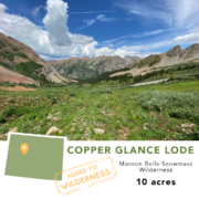
out much of Colorado’s high country, including deep in what today is designated wilderness, traces of mining history can be found, from mine shafts still framed in timbers to bits of rusted machinery and bean cans. The majority of these silver, gold, and copper mines were small-scale, and the landscapes around them have recovered quickly, wiping away most traces of their camps and wagon trails. These small operations were certainly much different than the kinds of mega-mines we see today, removing entire mountain tops and reshaping vast landscapes to access ore. But they still serve as a reminder of what could have been. Had the boom not turned to bust so quickly, or had the lasting protections of designated wilderness not been established 60 years ago, the basins and ridges of Colorado’s high country might have looked much different today, including those surrounding the Copper Glance Lode property.

Data from the Resilient Landscapes Mapping Tool

Our thinking on what these landscapes provide has also evolved. No longer are they valued primarily for the profit lying beneath their surface, but for their beauty, their recreational opportunities, and the role their ecosystems play in sustaining life. The 10-acre Copper Glance Lode property rates high for climate resilience, habitat connectivity, and landscape diversity, which means that not only does it play an important role in maintaining biodiversity and clean air and water today, but it will continue to as the climate changes.

Get more wilderness news delivered to your inbox!


By submitting this form, you are consenting to receive marketing emails from: Wilderness Land Trust. You can revoke your consent to receive emails at any time by using the SafeUnsubscribe® link, found at the bottom of every email. Emails are serviced by Constant Contact

The Trust goes to Washington DC!

March 8, 2024-

Members of our staff spent this week in Washington DC speaking with congressional and agency representatives about the importance of protecting wilderness.

Given that the Trust isn’t an advocacy organization, this isn’t a part of our day-to-day work. But the happenings in DC certainly affect our work, so once a year we take the opportunity to meet with decision-makers to discuss the role that protecting private lands in and around wilderness plays in the larger conservation effort.

One of the highlights of the trip was meeting with staffers of Senators Bennet and Hickenlooper, both of Colorado, to discuss our work to protect the 650-acre Snowmass Falls Ranch property in partnership with Pitkin County, CO. For this kind of large-scale project, valued at $34 million, building a broad base of support for the project is critical for the eventual successful transfer to public ownership. We enjoyed the opportunity to share about this incredible landscape with both Senate offices representing it.

Another topic of our meetings was the Land and Water Conservation Fund (LWCF). This year marks the 60th anniversary of the acts establishing both our national wilderness system, as well as this closely tied funding source. Funded by revenue from offshore oil and gas leases, LWCF supports everything from large conservation projects to new playgrounds and tennis courts in local parks across the country. Within the fund is an account specifically earmarked to acquire private wilderness inholdings, so we enjoyed meeting with members of the appropriation committees to share stories of the places these dollars help protect, and ask that the Critical Inholdings Account be fully funded. The trip was also an opportunity to catch up with some of our close partners, like the USFS National Land Acquisition Program Manager, who play a critical role in the success of our work every day.


Get more wilderness news delivered to your inbox!


By submitting this form, you are consenting to receive marketing emails from: Wilderness Land Trust. You can revoke your consent to receive emails at any time by using the SafeUnsubscribe® link, found at the bottom of every email. Emails are serviced by Constant Contact

New protections for Washington and California’s wild places

February 23, 2024-

Lands added to Henry M. Jackson Wilderness & Lassen National Forest

This week we are celebrating successful transfers of properties in California and Washington to public ownership! Both projects protect habitat important for maintaining biodiversity and improve connectivity across the landscape.

In northern California’s Lassen National Forest, 35 acres have been protected in an area proposed for future wilderness designation. The property provides an important connection between the proposed wilderness and Hat Creek, a trout fishery that Cal Trout and the Pit River Tribes have been working to restore. With good road access, the property was at high risk of development in the popular area for cabins and second homes just outside Lassen National Park. With the property’s addition to public lands, the road can be closed, adding to the roadless area eligible for wilderness designation.


The 15-acre West Seattle Lode property has been added to Washington’s Henry M. Jackson Wilderness. The property was our first acquisition in the wilderness area in 2022, which adjoins the Wild Sky Wilderness. This rugged, glaciated landscape is home to the endangered Northern Spotted Owl, Cascade red fox, pika, wolverines, and Marbled Murrelet, a seabird that nests in old-growth forests and alpine slopes. The property is on a steep slope that overlooks the Monte Cristo ghost town, the site of a gold and silver mining boom lasting from 1895-1912, and a popular hiking destination.

The Hat Creek and West Seattle Lode projects are great examples of how protecting small properties can have positive impacts that reach well beyond their boundaries.


Get more wilderness news delivered to your inbox!


By submitting this form, you are consenting to receive marketing emails from: Wilderness Land Trust. You can revoke your consent to receive emails at any time by using the SafeUnsubscribe® link, found at the bottom of every email. Emails are serviced by Constant Contact