Tag Archive for: conservation

650-acre Snowmass Falls Ranch protected in landmark conservation deal

February 9, 2024-

The Wilderness Land Trust is partnering with Pitkin County in a landmark conservation deal to protect the 650-acre Snowmass Falls Ranch just outside of Snowmass Village conserving two miles of valley floor filled with aspen meadows, beaver ponds, trout streams, and public trails.

Located at the foot of the Elk Range, the majority of the property lies within the boundaries of the Maroon Bells-Snowmass Wilderness. The ranch is home to diverse wilderness values: open meadows, aspen groves, spruce forest, wetlands, and riparian shrublands create a mosaic of habitat types that support a wide range of flora and fauna. It provides summer range for elk, bear, moose, mule deer, and mountain lion and hosts an active beaver complex and many bird species. A popular public trail runs through the ranch, serving as an important access point for hikers to the wilderness area. In addition to its ecological and recreation value, the ranch also holds the most senior water rights to Snowmass Creek, a significant source of water for the valley below.

This week Pitkin County purchased the property for $34 M using Open Space Program funds. The ultimate goal is to transfer the majority of the property to public ownership as National Forest to be added to the Maroon-Bells Snowmass Wilderness. This will also allow Pitkin County to recoup most of the purchase price to reinvest in other conservation and community projects. In the interest of future management and stewardship, it is possible that a small portion including existing cabins will end up in private ownership, ideally with a conservation easement. As a project partner, the Trust’s primary roles are to help determine these boundaries with the goal of maximizing the portion to become Wilderness, and to help secure LWCF funding for the ultimate transfer to public ownership.

Within the high-end real estate market of Aspen and surrounding Pitkin County communities, properties of this size are rare and highly sought after. Currently the property is largely undeveloped, with a small cluster of primitive cabins and a public trailhead on its east side, leaving the majority of it intact and connected habitat. This conservation project is only possible today because of the caring stewardship of the property by the private owners over the last 80 years—they are a wonderful example of how conservation values can be protected under private ownership. But the likelihood of another conservation-minded buyer stepping forward when the property was listed for sale was slim, and if not protected it could have been subdivided into up to six lots and developed.

Both The Wilderness Land Trust and Pitkin County have been pursuing a conservation solution for the property for many years, and the once in a generation opportunity to protect it has finally come to fruition.

Last threat of development removed from the sacred Blanca Peak

January 26, 2024-

The Wilderness Land Trust recently accepted a donation of 45 acres on the slopes of Blanca Peak, removing the last private property from the peak.

Blanca Peak stands at over 14,300 feet just outside of the Sangre de Cristo Wilderness in southern Colorado. But the peak is also known by another name, one that predates the Spanish descriptor of its near-vertical white slopes by centuries.

For the Dinè, or Navajo, the peak is Sisnaajiní. It is one of the four corners marking the boundary of the Dinetah, the traditional Dinè homeland, along with three other sacred mountains— Dibé Nitsaa in the north (Hesperus Mountain in the La Plata Mountain range of Colorado), Doko’o’osliid in the west (Humphrey Peak in the San Francisco Peaks of Northern Arizona), and Tsoodzil in the south (Mt. Taylor Peak, west of Albuquerque, New Mexico).

More than just a location marker, Sisnaajiní is known as an internal compass, orienting one’s mind and physical presence on earth. Like the sun rising in the east, Sisnaajiní represents thought, the place where each day, and each action, begins. It was a gift from the Holy People to the Dinè: “When the Holy People had assembled the things with which to dress the East mountain, they traveled by way of a sunbeam and rainbow beam to decorate Sisnaajiní. The Holy People dressed Sisnaajiní with a perfect white shell for positive thoughts and thinking. Then the Holy People ran a bolt of lighting through a sacred mountain to fasten the East mountain to our Mother Earth.” (Navajopeople.org)

Beginning in the 1890s the slopes of Blanca Peak were mined for silver and gold, the mining claims eventually leading to a number of private inholdings surrounded by National Forest, some with a road leading to them. When the Sangre de Cristo Wilderness was designated in 1993, a strip of land along the Huerfano River where the access road runs, was excluded from the wilderness area, cutting it in two.

While hiking into the nearby Lily Lake for a fishing trip in the early 2000s, David Carrick of Boulder, CO fell in love with the area, and after discovering how many private properties were still spread throughout it, he began buying them. Inspired by his love for public lands, David had a company helping to facilitate land transfers, and through one was able to transfer all but six of the private properties on Blanca Peak to public ownership. With a road leading to them, the remaining properties had a high risk of development, and David was approached with interest to buy them and develop them with cabins. But David, and his wife Pamela, chose a different path. Instead they donated the remaining six Blanca Peak properties to The Wilderness Land Trust. “I wasn’t familiar with the Trust previously, but as I started looking into them and understanding how they work, we felt confident that if we handed the properties over to them, they would be able to hold them until they could become public lands, which is what we wanted to see,” says David.

Thanks to the generosity of David and Pamela, and their commitment to seeing the landscape around Blanca Peak unified as public lands, the Trust has now begun the work of transferring the properties to the National Forest. With it no longer providing access to the private properties, the hope is that the road running along the Huerfano River can be converted to a trail, and someday the fracture through the wilderness area can be closed. With the last private properties removed, this sacred mountain is protected, ensuring it is open for future generations of Dinè for cultural and spiritual practices, as well as future generations of mountaineers inspired by its challenging climb.


Get more wilderness news in your inbox!

Priest Wilderness connection protected in the Trust’s first East Coast Project

January 12, 2024-

Priest Wilderness connection protected in the Trust’s first East Coast project

The Wilderness Land Trust has acquired 10 acres of valley forest directly connecting the Tye River and Priest Wilderness of Virginia, ensuring that habitat connectivity, watershed protection, and the wilderness experience of thousands of visitors a year is not interrupted by the threat of development.

This week we are celebrating a new acquisition adjoining Virginia’s Priest Wilderness, not just for the habitat it will directly protect, but as a major milestone for our organization. In 2022 the Trust set a strategic goal to expand our work east of the Rockies in response to a growing need to protect lands in and around the often smaller wilderness areas of the East. With little buffer of public lands surrounding them, they are particularly vulnerable to the impacts of private development at their borders. The Tye River acquisition marks a first step in pursuing this goal, and is also a prime example of its importance.

Only a few hours’ drive away, the 6,000-acre Priest Wilderness provides access to life-changing wilderness experiences for the millions of residents of Richmond, Virginia, and the Washington DC metro area. The Tye River, a tributary of the James River, is one of the most scenic and popular recreational waterways in Virginia, and provides critical habitat to dozens of species of fish and aquatic wildlife. The famed Appalachian Trail also runs through the Priest Wilderness, only a few miles from the Tye River project. The George Washington National Forest, where the Priest Wilderness is located, provides drinking water for over 4 million people, and is part of the imperiled Chesapeake Bay Watershed. Protecting intact ecosystems in the watershed is critical to its health and the supply of clean, safe drinking water.

The Priest Wilderness and Tye River connect over the span of only a mile, creating an important link in habitat connectivity for species like black bears, peregrine falcons, and lady’s slipper orchids. The Tye River property sits in the middle of this connection, and its protection ensures this important link will remain intact.

As with almost all of our projects, local community partnerships played an important role in the success of the project. The property was first brought to the Trust’s attention by the Virginia Wilderness Committee, which helped to secure wilderness designation for the Priest Wilderness in 2000. “The acquisition of this small parcel of land along the Tye River, closes an important gap in land adjacent to The Priest and will protect The Priest Wilderness from the sights and sounds of future development” says Ellen Stuart-Haëntjens, Executive Director of Virginia Wilderness Committee.

Get more wilderness news in your inbox!

The Wilderness Land Trust to partner with Pitkin County, CO in protecting 650 acre property

January 5, 2024-

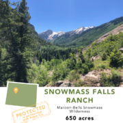
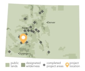
The Wilderness Land Trust is delighted to be partnering with Pitkin County, CO in a landmark conservation deal to protect the 650-acre Snowmass Falls Ranch. For more information on the project, see the County announcement below. 


Pitkin County poised to make historic open space purchase

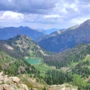
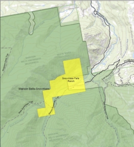
PITKIN COUNTY, CO – A $34 million open space acquisition that will preserve 650 stunning acres in the upper Snowmass Creek Valley, bounded on three sides by the Maroon Bells-Snowmass Wilderness Area, will go to Pitkin County commissioners for initial approval on Jan. 10.

The Pitkin County Open Space and Trails Board voted unanimously to recommend the purchase at its meeting Thursday, Jan. 4, in Redstone.

“Snowmass Falls Ranch is quite easily the most extraordinary piece of private land in Pitkin County,” said Dale Will, acquisition and projects director for Open Space and Trails. The property was listed for sale in 2021 for $50 million though the county has been working diligently on a conservation deal since 2019. “We’ve held our breath since the property was listed, but never gave up on the hope that the ranch could be preserved,” Will said. “It will be an outstanding addition to the public lands of Pitkin County.”

Once part of the vast territory of the Ute People, the ranch was established by Danish immigrant Kate Lindvig in the early 1900s. Known as the “Cattle Queen of Snow Mass,” she assembled the land in various parcels over several years through the Homestead Act and other purchases. She continued to run the ranch as a single woman until she sold the land in 1943 to Bob Perry, his wife Ruth Brown Perry, and Ruth’s brother, D.R.C. Brown, Jr. Bob and Ruth Perry became the sole owners in the early 1950s. The ranch has remained in the Perry family for 80 years; it is now owned by a company called Perry Family Snowmass, LLC, comprised of Bob and Ruth Perry’s descendants.

Reached through the LLC’s attorney and designated spokesperson, Bart Johnson, Perry Family Snowmass offered, “The Perrys have been stewards of this special and unique property for eight decades. Not surprisingly, it is with mixed emotions that they have agreed to sell Snowmass Falls Ranch, but after careful deliberation, Perry Family Snowmass, LLC has decided that Pitkin County is the right buyer at the right time.”

The purchase price for Snowmass Falls Ranch far eclipses any other open space acquisition in the history of the county’s Open Space and Trails program, noted Gary Tennenbaum, program director. It is double the cost of the purchase of about 845 acres at the heart of Sky Mountain Park, acquired for $17 million in 2010. Great Outdoors Colorado (GOCO), the Town of Snowmass Village, City of Aspen and private donors contributed to the Sky Mountain purchase, bringing the county’s contribution down to roughly $11 million.

“Fortunately, we are in an opportune position to make this purchase happen right now,” Tennenbaum said. The Open Space program has $34 million in its fund balance.

“In 2020, the BOCC and Open Space and Trails Board had the vision to issue bonds for the remaining $20 million in borrowing capacity that had been previously authorized by voters,” Tennenbaum said. Interest rates were historically low in 2020 and, with the county’s excellent credit, the program received a premium on the bond, netting over $24 million. The bonds helped provide the capacity to complete this legacy acquisition, he said.

At their Jan. 10 meeting, county commissioners will also work on setting the Open Space and Trails fund mill levy. They will have to balance the desire for property tax relief with the reality of providing future capacity for the program. There are yet more properties that have open space values to acquire, and trail projects to complete, throughout the county, Tennenbaum said.

The Open Space program has applied for a 3-year, $10 million loan from GOCO to assist with the Snowmass Falls purchase and ultimately hopes to transfer much of the property for inclusion in the Maroon Bells-Snowmass Wilderness Area. Much of the ranch has a wilderness designation overlay, but since it remains private property, none of the wilderness protections apply. The county will be working with The Wilderness Land Trust and the Forest Service to determine how much of the property can be transferred and how much of the purchase price can be recouped by Pitkin County.

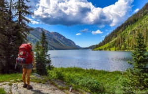
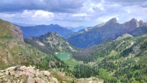
Snowmass Falls Ranch already provides a key portal to the wilderness area. Both the Snowmass Lake Trail and West Snowmass Trail cross through the property on easements that Lindvig deeded to the national forest in 1933.

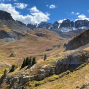
The ranch encompasses two miles of the glacial valley located west of Snowmass Village. It is filled with aspen meadows, beaver ponds and trout streams at the foot of the high peaks of the Elk Mountains. Five meadows are irrigated with the most senior water rights on Snowmass Creek and, tucked out of view, is Snowmass Falls – the feature that gives the ranch its name. It’s one of two waterfalls on the property.

“Seeing this extraordinary property protected from further development under public ownership has been a long-standing goal of The Wilderness Land Trust,” said Brad Borst, Land Trust president. “We are delighted to partner with Pitkin County with the hopes of ultimately adding this critical wildlife habitat and public trails to the Maroon Bells-Snowmass Wilderness.”

A parcel containing five off-grid cabins – the only developments made to the ranch in the Perrys’ long stewardship – could be carved out of the rest of the ranch. It’s possible the piece could be sold, but with a conservation easement in place to establish parameters for its use and further development, Tennenbaum said.

In the short term, improvements to the existing Snowmass Lake trailhead, just outside of the ranch gate, could be made using flat ground just inside the ranch, Tennenbaum said. The current trailhead parking area lacks a functional design and is frequently at capacity.

“We hope to transfer most of the ranch to the Forest Service as soon as possible, but for now, this amazing property will be open space,” Tennenbaum said. “It’s an incredible asset but also a huge responsibility.

“The ranch remains private property until this potential transaction is consummated, Tennenbaum added. “We trust the public will respect private property during the interim period.”

On Tennenbaum’s recommendation, the Open Space and Trails Board decided the property will be closed to the public when the county takes ownership, while Open Space and Trails works on an interim plan for its management.

Contacts: Gary Tennenbaum | Open Space and Trails director | gary.tennenbaum@pitkincounty.com | 970-920-5355

Dale Will, OST acquisition and projects director | dale.will@pitkincounty.com | 970-618-5708
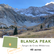
Get more wilderness news in your inbox!

Mendocino National Forest grows by 917 acres

December 12, 2023-

The Wilderness Land Trust recently transferred 917 acres adjacent to California’s Sanhedrin Wilderness to public ownership.

In northern California’s Mendocino County, tucked between the Wild and Scenic Eel River and peaks of the Sanhedrin Wilderness, 917 acres of formerly private land have been transferred to public ownership. The property, known as the Thomas Creek project, provides a link between lower-elevation habitats and the mature fir forests that blanket the high country, as well as a critical wildlife corridor between the Sanhedrin Wilderness to the north and other National Forest lands to the south.

Its rolling hills are spotted with protected oak savannah and groves of madrone trees, home to a thriving community of rare plants, spotted owls, martens, bears, mountain lions, and deer.  Among the rare plant species is the Anthony Peak lupine which only grows in Mendocino National Forest. The property also contains one of the last private sections of Thomas Creek, an important tributary to the Eel River, and critical spawning grounds for its steelhead and coho salmon fisheries.

The Thomas Creek project scored as a high conservation priority for the Trust and National Forest for its climate change resilience value and high threat of development with the potential to be subdivided into six building sites.

“The Thomas Creek project meets the mark for all the benefits of designating public lands – it’s going to protect critical habitat and treasured species, support biodiversity, and get us closer to our conservation and climate goals. I’m incredibly grateful to the Wilderness Land Trust and the Mendocino National Forest for stepping up as stewards of this land.”   – Congressman Jared Huffman

Due to its importance in regional conservation efforts, the project has also gained support from the Backcountry Hunters and Anglers California Chapter, CalWild, Friends of the Eel River, Redwood Chapter of the Sierra Club, and Willits Environmental Center.

The Wilderness Land Trust purchased the property in October 2022. The Trust had previously purchased another property from the private owner in 2011. With this established relationship, the landowner trusted the Wilderness Land Trust and Mendocino National Forest would ensure its protection for future generations. For the last year, the Trust has been working with Forest Service leadership at Mendocino National Forest, the regional office, and Washington D.C. to complete the transfer of this important landscape to public hands. The transfer to public ownership was made possible by Land and Water Conservation (LWCF) funds with support from Rep. Huffman and the late Sen. Feinstein.

Get more wilderness news in your inbox!

Protecting the slopes of Mount Champion

December 1, 2023-

The Wilderness Land Trust recently acquired 275 acres on the slopes of Mount Champion, just outside Colorado’s Mt. Massive Wilderness.

Less than an hour from the Roaring Fork Valley, locals and visitors have long been drawn to Independence Pass for its panoramic vistas and recreation opportunities for all ages and abilities. Mount Champion stands tall above the pass and, while the area is a popular destination, much of the peak’s south and west faces have been privately owned and at risk of development.

This month Amy Margerum Berg, owner of 275-acres on the west face of Mount Champion, generously donated the property to The Wilderness Land Trust to be subsequently transferred to public ownership in San Isabel National Forest. The property stretches from the North Fork of Lake Creek almost to the summit and includes remnants of the Champion Mine which was active from 1907-1940 mining gold, silver, copper, and lead.

“My late husband, Charles “Chuck” McLean, had the foresight to purchase these mining claims with the intent of protecting them from development. My son, Slater McLean, and I are so proud to be donating this land in his honor. He loved this land more than anything and spent hours exploring and hiking every inch of this spectacular backcountry wilderness. He would be very happy to know that the land will now be protected forever,” says Amy Margerum Berg.

The popular North Fork Lake Creek Trail leads hikers, backpackers, and horsemen into the 30,000-acre Mount Massive Wilderness and runs through the base of the donated property. Protecting the property under public ownership will ensure public access on the trail and mitigate the management and liability concerns that have recently cut off access to several of Colorado’s 14ers. The donation also protects important wildlife habitat, spanning from streamside riparian zones to alpine meadows above treeline, and is home to bighorn sheep.

The Champion Mine South property is just up the drainage from the 20-acre Blue Lake property which The Trust added to designated wilderness last year, removing the last remaining inholding in the Mount Massive Wilderness.

Get more wilderness news in your inbox!

17 more Colorado properties protected!

November 17, 2023-

This week The Wilderness Land Trust completed the purchase of 17 properties totaling 162 in and around the Handies Peak and Red Cloud Wilderness Study Areas in Colorado. 

Near Silverton and Lake City, the Handies Peak and Red Cloud Wilderness Study Areas draw a wide variety of recreationists. Several of the acquired properties are located near the trailhead and trail to American Basin, one of the most iconic scenic vistas in Colorado. The Alpine Gulch Trail runs through another of the properties. These two wilderness study areas have been recommended for designation as wilderness and are included in the Colorado Wilderness Act which has been passed by the US House and awaits a Senate vote. In removing these potential future wilderness inholdings before the wilderness is designated, we are helping to avoid management conflicts, including for public access, before they arise.

The area also has significant ecological value. In addition to being home to Bighorn Sheep and the endangered Uncompahgre Fritillary Butterfly, some of the properties are within a one-mile corridor separating the proposed wilderness with the already designated Uncompahgre Wilderness. Safeguarding against development in these wildlife corridors is important in the landscape-scale protection needed to build climate resilience in our wild places. The Handies Peak WSA also includes the headwaters of the Gunnison River, Animas River, and Rio Grande, which supply drinking water to many downstream communities.

The properties are accessed by the Alpine Loop Backcountry Byway, a very popular OHV route that traverses 63 miles through the alpine on roads built during the mining boom, including over Cinnamon and Engineer Pass. The properties’ proximity to this popular motorized route put them at especially high risk for development. In fact, while visiting the properties our lands specialists saw several newly constructed cabins on other nearby private properties. Real estate prices in the area for these remote properties are considerably higher than in other parts of Colorado, and are only rising. All of this makes protecting these properties not only critical, but urgent. There are still many remaining private inholdings in the area which the Trust is pursuing. As we near the end of the year and its accompanied fundraising drive, your continued support will help move these 17 properties through the transfer process, placing them in public ownership for generations to come, and will help us to protect more private properties in the area.


Get more wilderness news in your inbox!

Introducing the Wilderness Book Club

October 20, 2023-

Introducing The Wilderness Book Club!

With autumn leaves turning and the first frosts greeting the dawn, it won’t be long before the snow drives many of us indoors from our favorite wilderness trails. To celebrate the start of this cozy season we’re excited to introduce our new Wilderness Book Club!

Every other month we’ll select a book, non-fiction or fiction, that explores wilderness, conservation, wildlife, and adventure from a wide range of voices. You can read along and send us your thoughts and reflections about the book which we’ll share on the website for the rest of the club. You can also send us your book recommendations!

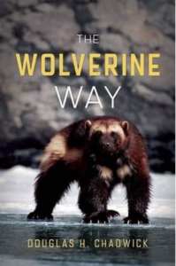
October Wilderness Book Club Pick:

The Wolverine Way

by Douglas H. Chadwick

The wolverine comes marked with a reputation based on myth and fancy. Yet this enigmatic animal is more complex than the legends that surround it. With a shrinking wilderness and global warming, the future of the wolverine is uncertain. The Wolverine Way reveals the natural history of this species and the forces that threaten its future, engagingly told by Douglas Chadwick, a biologist with the Glacier Wolverine Project.

This month’s pick was recommended by Margosia, our Director of Marketing & Communications: “I first read The Wolverine Way a few winters ago after leading some bear-aware programs with the author Doug Chadwick. All that winter while out skiing, especially in Glacier NP, I annoyed my family and friends with constant wolverine facts and stories from it. I couldn’t help it though, the book was so interesting!”

Send us your thoughts and reflections on The Wolverine Way by December 18th

Share the Wilderness Book Club with your reader friends and have them sign up for our email newsletter to hear about the latest book picks.

What it means to keep our wilderness wild: defining the character of wilderness

October 6, 2023-

When asked what wilderness is, many people will quote some portion of the 1964 Wilderness Act’s definition of “A wilderness, in contrast with those areas where man and his works dominate the landscape, is hereby recognized as an area where the earth and its community of life are untrammeled by man, where man himself is a visitor who does not remain.” For many of us who have spent time in wilderness, developing our own personal relationships with it, our definitions will also cross into how we have experienced wilderness, how we love to explore it, or how it makes us feel.

In the Trust’s work to protect wilderness, we often refer to wilderness character in terms of how development of an inholding would affect the wilderness character of the lands around it, or how we will work to restore lands to their wilderness character before they are transferred to public ownership. It’s a term that is often used as a catch-all for everything from ecosystem health to solitude. But the Wilderness Act actually goes on to define wilderness character with five tangible and measurable characteristics: 

Beyond defining these wilderness characteristics, the law also sets a requirement for the managing agency to maintain or improve these characteristics in a wilderness area from the time of its designation forward. In the last 15 or 20 years a standardized system for monitoring and evaluating wilderness characteristics has been developed. For each of these characteristics is a set of indicators that can be assessed for a negative change, no change, or positive change for an area year after year. These indicators range from actions authorized by the federal land manager that intentionally manipulate the biophysical environment for untrammeled character, to human-caused change to air or water quality for natural character, to the presence of inholdings for undeveloped character. Observing trends in these indicators can help to identify stewardship needs and successes. 

For the vast majority of wilderness visitors, these indicators fade into their overall experience of wilderness. We may notice signs of their change like new fire rings popping up along popular backpacking routes through the years, or our phones pinging for the first time with incoming messages as we enter a new patch of cell service on a familiar trail. But it is how wilderness exists outside of our experiences of it, in our absence, that is really at the heart of its character. It is what is left behind when we, the visitors, go: the ecological integrity, free flow of natural cycles, and the existence of a few last corners of the earth not shaped and controlled by human civilization. 

Learning more about wilderness character monitoring here.

A Tale of Two Emerald Lakes: Protecting Colorado’s Weminuche Wilderness

September 22, 2023-

The Trust recently completed the transfer of a 7.5-acre property on the slopes above Emerald Lake in the heart of Colorado’s Weminuche Wilderness. The project builds on two adjacent properties which the Trust already transferred into public ownership to be added to the wilderness area in 2020.

You may have heard of Emerald Lake as a popular backpacking destination in the Weminuche Wilderness. If you have, it’s almost certainly another Emerald Lake. Somewhat confusingly there are two named Emerald Lakes in the wilderness area (plus a Little Emerald Lake), and while both are accurately named for their emerald green waters, they are quite different. The Emerald Lake you may know is an hour’s drive and ten-mile hike from the small city of Durango. Sitting at 10,000 feet it is the third largest natural lake in Colorado and attracts backpackers ranging from solo hikers to families to groups of Boy and Girl Scouts. Local outfitters also guide horse packing trips to a site just above the lake. Generations of wilderness visitors have come to camp along Emerald Lake, some on their first backcountry tip, to see the vivid Milky Way reflected in its still waters, to listen to great horned owls calling through the treetops, and to watch the sun rise over the eastern ridge. 

A backpacker at the popular Emerald Lake (Photo by Alex Gulsby from VisitDurango.org)

The Emerald Lake of the Trust’s recent transfer is some 13 miles west of the popular Emerald Lake and is 3% of the size. This Emerald Lake sits just above treeline at 11,300 feet and is surrounded by fragile alpine tundra. It’s about a mile and 1,500 ft climb through a dense drainage from the nearest trail and attracts very few and only the most intrepid of wilderness visitors. Alpine lakes like this serve as important biodiversity hotspots in the harsh high-elevation environment. The Trust’s work to protect even small properties in these areas conserves habitat for wildlife and rare plants like Heil’s Tansy Mustard.

The ‘other’ Emerald Lake viewed from the Trust’s recently transferred property

While very different, both Emerald Lakes play important roles in our national wilderness landscape. We need wild places where families can go to unplug and explore together, just as we need wild places void of popular trails and campsites where wildlife can move unencumbered by human presence. Visitation to our National Forests increased by more than 20 million between 2016 and 2019 and skyrocketed by another 18 million from just 2019 to 2020. This trend was even more pronounced in wilderness areas where visitation almost doubled in 2020 after four years of minimal growth. These statistics represent many more people, and more diverse people, having the opportunity for life-changing wilderness experiences for the first time. And that’s something to celebrate in its own right. But it can also put a strain on natural resources and managing agencies. In 2021 USFS crews picked up 397 contractor-sized trash bags of garbage in the Columbine Ranger District, where the Weminuche Wilderness is located, showing the need for education to teach all visitors, whether it is their first visit or hundredth visit, how to recreate responsibly and leave no trace.

Growing visitation also shows how important it is to protect places like the ‘other’ Emerald Lake from threats of development. Our work to protect these places, largely unknown and unglamorous in the public eye, is critical in balancing the needs of wilderness landscapes and ensuring a refuge for nature and nature alone.