
A Science-based approach to wilderness protection
June 5, 2023- You’ve likely heard us refer to climate resilience in relation to our work protecting lands in and around wilderness areas from development. Generally speaking, climate resilience is the ability to anticipate and respond to events, trends, and disturbances related to the changing climate. Climate resilience is something that can be built: we can make our communities and cities more resilient through planning to anticipate effects on our drinking water supplies, floodplains, or wildfire protection. We can also help make our natural landscapes more resilient through thoughtful management and habitat restoration. But some landscapes are also inherently more resilient on their own. Resilient landscapes tend to have high microclimatic diversity— or variation in factors like temperature, precipitation, humidity, or wind speed across the landscape— and low levels of human modification. Together these conditions provide the connected and diverse habitats that flora and fauna will need to adapt to a changing climate.
Wilderness areas tend to rank high in both of these conditions— they are large enough to encompass diverse habitats from cool north-facing gullies to lush alpine meadows to dry sagebrush scrub, and as the highest level of protection for public lands in the US, they have little modification by humans. But understanding how climate resilience varies across wilderness landscapes is also becoming increasingly important for the Trust as we prioritize which areas and properties to protect.
The scientific community, aided by developing technologies like satellite remote sensing, has steadily been building databases of different measures of climate resilience, biodiversity, habitat connectivity, wildlife migration paths, and more. Many of these are now publicly available through tools like The Climate Atlas and The Nature Conservancy’s Resilient Land Mapping. If you’re interested in these issues, or just love maps, these tools are fun to explore and are excellent ways to learn more about your local area or wild places you love.
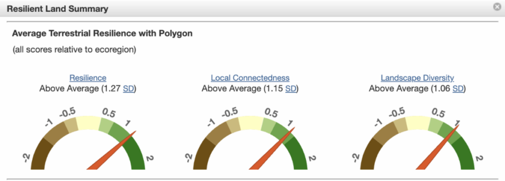
This analysis of the Silver Creek drainage in Washington’s Wild Sky Wilderness, where the Trust has completed a number of projects, shows it scores above average in resilience, connectivity, and landscape diversity. (Analysis from Resilient Lands Mapping Tool)
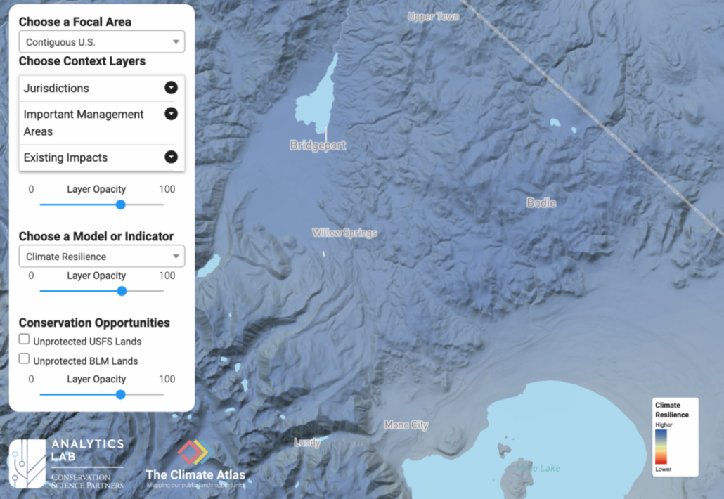
Using The Climate Atlas, we can not only see how the Bodie Hills in the eastern Sierra of California (where the Trust has also completed several projects) have high climate resilience, but also how they fit into a larger resilient ecoregion. (Mapping from The Climate Atlas).
This kind of data, along with boots-on-the-ground site visits by our staff, and partnerships with local agencies and organizations, allow us to dive deep into potential projects and understand all the conservation values at stake in their protection. Climate resilience is just one of the criteria that we evaluate potential projects on, but when we talk about protecting our wild places for future generations, it is an increasingly important one. Through a science-based approach we are able to able to ensure that your donations are being leveraged to have the greatest impact.


")


")